
Fundamental Value of the Landscape
OV4 Green Infrastructure Network
OV5 Local Green Space
OV6 Grade 1 & 2 Agricultural Land
OV4 Green Infrastructure Network
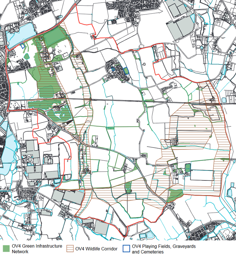
A. The parish contains a variety of green and blue infrastructure that provides an
environmental support system for the community and wildlife. The Neighbourhood
Plan designates this as a Network, as shown on the Policies Map, which comprises
land with known biodiversity value, including defined wildlife corridors, priority
habitats, water vole networks, bat and barn owl habitats, woodlands, significant
hedgerows and lines of trees, streams and other water bodies as well as amenity
space.
B. Development proposals that lie within or adjoining the Network are required, where
relevant, to have full regard to creating, maintaining and improving the Network,
including delivering a net gain to general biodiversity value and wildlife connectivity,
in the design of their layouts, landscaping schemes and public open space and play
provisions.
C. Proposals that will harm or lead to the loss of land lying within the Network and
that will undermine its integrity will not be supported. Development proposals that will
lead to the extension of the Network will be supported, provided they are consistent
with all other relevant policies of the development plan.
D. The Policies Map shows those parts of the designated Network that are known or
likely to have biodiversity value either as habitat areas; as hedgerows or lines of trees;
or as streams and rivers. When calculating Biodiversity Net Gain requirements using
DEFRA’s latest metric, development proposals located within or adjoining that part of
the Network should anticipate achieving at least a medium distinctiveness multiplier
score.
E. Biodiversity should be provided on-site within the Neighbourhood Plan area wherever
possible. Off-site measures will only be considered where it can be demonstrated
that, after following the mitigation hierarchy, all reasonable opportunities to achieve
measurable net gains on-site have been exhausted or where greater gains can be
delivered off-site through maximising local place making and nature improvement
opportunities.
Background
Wildlife corridors have been identified as key habitats for nesting, foraging and
transportation routes for wildlife. The LPA is in the process of determining wildlife
corridors running through the parish from Westhampnett to Pagham Harbour.
Supporting text
This policy will support the development of a nature recovery plan to increase biodiversity, connectivity and functionality to protect Schedule 1 species and European Protected Species.
The recovery plan would seek to provide a suitable habitat to accommodate the effects of climate change and the resultant changes in species movements. The main objectives should include:
a) enhancing and improving woodland and riparian zones (ditch habitats);
b) addressing and reducing the effects of night-time lighting issues;
c) improving the connectivity of these habitats along the corridor;
d) increasing the buffer zones around these corridors to protect against the harmful effect of
human interaction and development on nature
in order to create a habitat to increase the prevalence of Schedule 1 and European protected
species, but particularly protecting and increasing already identified species along these
corridors including but not limited to otters, bats (list species), water voles, door mice and
hen harriers.
The plan would include a programme of small discrete stages for habitat creation or improvement over a ten year period as follows:
a) Complete baseline survey data (static surveys, ornithological surveys, bat tagging survey, photographic evidence to feed into Sussex Biodiversity Record Centre
b) Develop an enhancement and management plan consisting of the improvement of connectivity between habitats; water management plan to include junction ponds and coir rolls to increase wetland habitat, especially during periods of drought; enhancement of buffer zones through increased planting.
There would also need to be a system using baseline data as above and continual recording (survey, static cameras and photograph evidence) to maintain and monitor these habitats and the wildlife that lives in them.
Local Planning Policy Context
Policy OV4 accords with Chichester Local Plan 2014-2029 policies 49 and 52 in requiring proposals, where relevant, to enhance and extend the green infrastructure network, as identified on the Policies Map. This accordance also extends to the emerging Chichester Local Plan 2021-2039 policies NE4, NE5, NE8, P14 and P15. The wildlife corridor element of OV4 anticipates the identification and adoption of wildlife corridors in policy NE4 of the emerging Local Plan.
OV5 Local Green Spaces
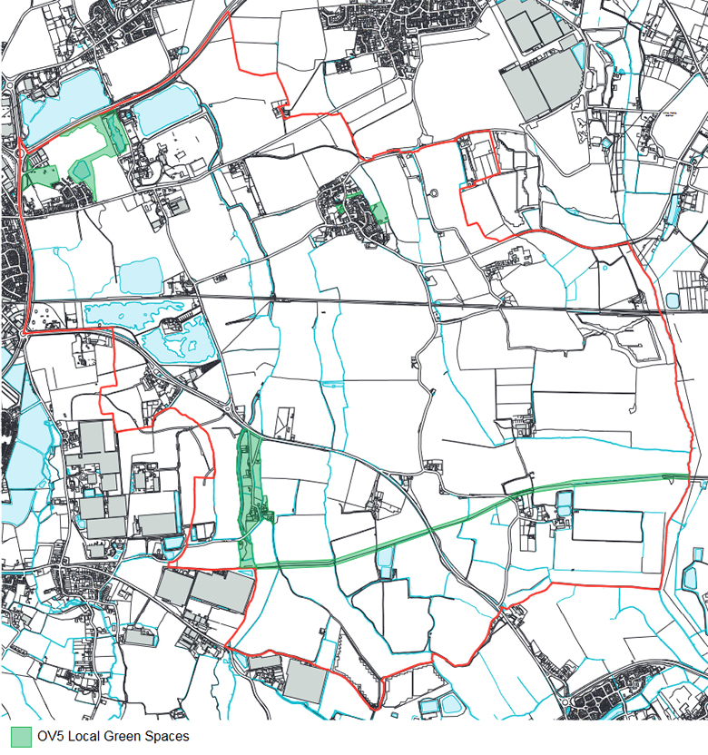
The Neighbourhood Plan designates the following Local Green Spaces, as shown on the Policies Map:
- Diamond Jubilee Park in Oving Villag
- Cemetery off Church Lane, Oving
- Narrow pasture land either side of Marsh Lane, Merston
- Land to east of (grade 1 listed) Church of St Giles, Merston
- Route of former Chichester/ Arundel canal in Merston and Colworth
- Green Spaces within the Shopwyke Lakes and Redrow estates
- The old road route from Church Lane to Woodfield house
Introduction/ purpose
The NPPF states that “the designation of land as Local Green Space through local and
neighbourhood plans allows communities to identify and protect green areas of particular
importance to them.” In addition: The Local Green Space designation should only be used
where the green space is:
(a) in reasonably close proximity to the community it serves;
(b) demonstrably special to a local community and holds a particular local significance, for example because of its beauty, historic significance, recreational value (including as aplaying field), tranquillity or richness of its wildlife; and is
(c) local in character and not an extensive tract of land.
A designation has the policy effect of the equivalence of the Green Belt in terms of the
definition of ‘inappropriate development’, consistent with paragraph 103and 147 of the
NPPF and of the ‘very special circumstances’ tests in the NPPF when determining planning
applications located within a designated Local Green Space.
Background
Oving Parish Council engaged consultants terra firma in June 2021 to undertake a parish
study to establish if there were areas that could be proposed for designation that met the
NPPF criteria. The study concluded that there were eight such areas and these are accordingly
included in the Oving Neighbourhood Plan. See Appendix OV1 and associated LGS Analysis
Sheets.
Local Planning Policy Context
Policy OV5 accords with Chichester Local Plan 2014-2029 policy 54 and emerging Chichester Local Plan 2021-2039 policies P14 and P15. OV3 goes a step further by formally designating the identified spaces as Local Green Spaces.
References
The Terra Firma Consultancy Limited reports on Local Green Space and Oving Landscape Capacity (December 2021)
See Appendix OV5
OV6 Grade 1 & 2 Agricultural Land
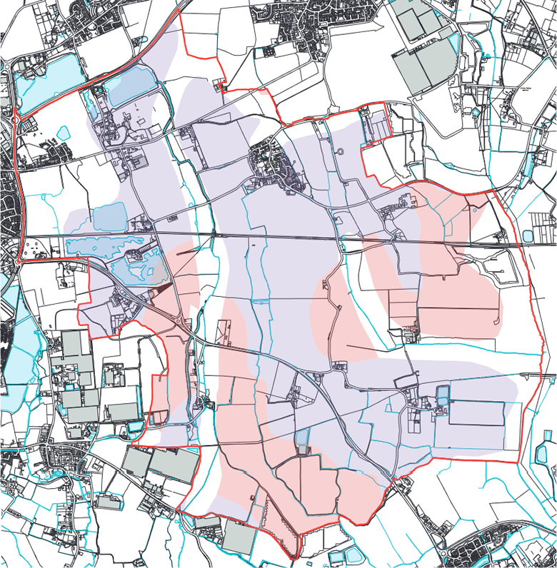
Development proposals which would diminish the capacity of soil classed as Grade I or Grade II, as shown on the Policies Map, will not be supported, unless:
I They are for the purpose of delivering a policy compliant scheme for either a New Local Service (Policy OV2), a Green Network Infrastructure improvement (Policy OV4), or an Active Travel Network improvement (Policy OV9) or:
II It can be demonstrated that there is no land of a lower agricultural land classification within the Parish or any adjoining Parish that is suitable for the development proposed.
Introduction
The policy seeks to protect one of the rarest soil types in the country and go beyond seeking to preserve the Best and most Versatile (BMV) soil as set out in the emerging Local Plan.
Supporting text
NPPF para 180
CDC LPR 2021-2039 Policy NE2
Local Planning Policy Context
Policy OV6 accords with Chichester Local Plan 2014-2029 policy 48 and emerging Chichester Local Plan 2021-2039 policy NE2 in seeking to guide development away from the most valuable agricultural land (Grade I or II).